 |
| An illustration of the probable size and location of the ocean on Mars. Image: University of Colorado |

Showing posts with label Mars. Show all posts
Showing posts with label Mars. Show all posts
June 16, 2010
An Ocean on Mars
March 3, 2010
Mars Express Passes by Phobos
The Mars Express spacecraft, built by the European Space Agency, flew by the Martian moon Phobos on Wednesday March 3. The pass was just 67 km (42 miles) away from the surface of Phobos, the shortest pass ever to the moon.
The goals of the flyby of Phobos was to learn about the structure of the moon. The Mars Express spacecraft measured the small deviations to its motion from the gravitational field of Phobos. These measurements are extremely small and require a great amount of precision. The gravitational field experienced by the spacecraft is just a billionth of that it would experience on the Earth's surface. Even taking pictures from this extremely close pass was not allowed, since moving the shutter of the camera, among other movements, would change the measurements taken by the spacecraft.
Phobos is one of the two moons of Mars, both of which are characterized by their small and irregular shape. Their masses are not large enough to have made a round sphere during their formations, and they are instead lumpy and potato shaped.
The goals of the flyby of Phobos was to learn about the structure of the moon. The Mars Express spacecraft measured the small deviations to its motion from the gravitational field of Phobos. These measurements are extremely small and require a great amount of precision. The gravitational field experienced by the spacecraft is just a billionth of that it would experience on the Earth's surface. Even taking pictures from this extremely close pass was not allowed, since moving the shutter of the camera, among other movements, would change the measurements taken by the spacecraft.
Phobos is one of the two moons of Mars, both of which are characterized by their small and irregular shape. Their masses are not large enough to have made a round sphere during their formations, and they are instead lumpy and potato shaped.
January 22, 2010
Spirit's Rocky Situation

 Spirit, one of the Mars Exploration Rovers, is in a very rocky situation. Since April 2009, the rover has been embedded in a patch of rocky Martian soil. The dark and crusty ground, captured in the picture above by Spirit before its current predicament, broke through under the rover's wheels to reveal loose sandy soil, which trapped the wheels. Furthermore, when Spirit photographed its undercarriage (image at right) with its robotic arm, it revealed a rock potentially touching the robot.
February 28, 2009
Mars in Google Earth


 With the addition of surface imagery and terrain of Mars, Google was able to effectively create a very accurate 3D representation of Mars. To turn on the new Mars feature in Google Earth, just look for the space icon (left), and select Mars from the drop down menu. Flying around Mars is just as easy as it was zooming around Earth before. And just as Google Earth includes placemarks all over the Earth to provide interesting information about special locations, the Mars view does the same (right). Through these, you can find out about imager and the magnificent places on the red planet.
Plus, Google Earth 5 gives you the ability to talk to a real Martian through a hidden easter egg in Google Earth! Well, not really. Although this feature is just a computer program simulating talking, it is a fun addition to this big and valuable update to Google Earth. Just type "Meliza" into the search box, and look for the "MELIZA placemark with an icon looking like a robot.
Google Earth 5 does not just include Mars. With this update, the program now gives the ability to dive through the Earth's oceans and look at old satellite photographs. But I feel that both of these can't match up with the addition of a new planet!
You can download Google Earth 5 here.
Astronomy and Space celebrates International Year of Astronomy 2009.
June 23, 2008
Phoenix's Microscope Receives First Sample

After 28 Sols, or Martian days, the latest images beamed back to NASA from Phoenix, like the one above, show that the lander is continuing to do its job successfully on Mars. Phoenix's robotic arm, in the picture on the top right corner, has just recently picked up a small amount of soil from the Martian ground. Very carefully and gently, the arm sprinkled some of this soil onto the delivery port of the Optical Microscope which is fitted on the Phoenix lander.
The robotic arm is right now in an up position to hold the remaining soil. This soil may be later delivered to the Wet Chemistry Lab or the Thermal and Evolved Gas Analyzer. The researchers want the same type of soil sample to be delivered to all three instruments and analyzed so the findings from each instrument can be compared with those of the others.
Image from NASA.
May 26, 2008
Phoenix Landing a Success!

 Phoenix has made a successful landing on Mars yesterday. Very soon after the landing, it started sending pictures of itself and the area around it. The Phoenix crew (right) is very happy with the results.
The above picture is of one of Phoenix' landing pads. Each landing pad of the Phoenix spacecraft is approximately the size of a dinner plate. Notice that the landing pad is covered in dust. This is the result of the lander kicking up some of the soil during landing. However, most of the area around the lander is still in the original state. This is a good outcome since the Phoenix landing has not contaminated and affected the land, not affecting the research that Phoenix will later conduct.
To see the latest pictures that Phoenix has sent back, visit this page.
May 24, 2008
Seven Minutes of Terror!

Seven Minutes of Terror!
That's what the spacecraft and the team working on the Phoenix spacecraft will go through, when Phoenix attempts a landing this Sunday on Mars. This is when the space vehicle will first hit the atmosphere of Mars, go through parachute deployment, and finally hit the surface, with many more things in between. However, since signals between the Earth and Mars take about ten minutes to travel, the crew working on Phoenix will get the first signals that the landing process has started, after the whole landing sequence has actually ended! So how will Phoenix try to avoid the fate of many previous Martian missions and not splatter on the ground?
Phoenix will have the support of three Mars orbiters, that are currently circling the planet, NASA's Mars Reconnaissance Orbiter and the Mars Odyssey and ESA's Mars Express. The signals sent by Phoenix during its entry on to Mars will rely on the successful relay of the message to Earth by these orbiters. This is the first time any Mars lander will have the support of the relay system, both for landing and on the surface.
First, Phoenix will enter the Martian atmosphere at 21,000 km/h (13,000 m/h). A parachute, very similar to the Viking spacecrafts', will open at 12.6 km (7.8 miles) above Mars. The parachute will slow down the hurtling spacecraft with drag. Meanwhile, as Phoenix will near the surface, an onboard radar will give the altitude and velocity of the descent of the Phoenix spacecraft, allowing the onboard computer to make adjustments as necessary. This step is necessary, since upon entering and until the parachute opening, big errors in positioning can be made.
After two minutes of descent with the parachute, Phoenix will jettison its back shell, to which the parachute is attached. Then Phoenix will free fall, for half a second, towards the surface of Mars, and then ignite its engines. Nine engines from the total twelve will pulse for 10 seconds. The remaining three will fire steadily, for stability. Right before touchdown, as a finishing touch, the vehicle is turned, to increase the amount of sunlight that will fall on the solar panels.
The Jet Propulsion Laboratory will be able to give course adjustments if necessary up to three hours before Phoenix lands on Mars. However, during the landing, these people can only stand back, watch and hope, while they endure the seven minutes of terror.
The following video shows an animated launch and landing of the Phoenix, and gives a very nice visual of the above process:
Image from NASA.
May 23, 2008
Phoenix Components
The Phoenix spacecraft, launched in August 2007, is landing on Mars this Sunday. It is composed of many different types of components that will help conduct its research on Mars. Some of these instruments are from previous missions that did were abandoned.
One of the major components is the robotic arm. As said in the previous post, the robotic arm will help Phoenix to dig through the topsoil to reach the frozen water underneath. The arm will then bring up the samples up onto the lander for further analysis. This arm also has an attached camera, which allows Phoenix to see what and where it is digging.
There are various types of cameras on board the Phoenix. The Surface Stereo Imager is the primary camera on board, and is also a high resolution stereo camera. The Thermal and Evolved Gas Analyzer will bake and analyze martian dust. The Mars Descent Imager will take pictures of the Martian soil when the lander is descending, starting when the aeroshell is departed, at about 8 km above Mars. Using the Microscopy, Electrochemistry, and Conductivity Analyzer, researchers can examine Martian soil particles as small as 16 micrometers across.
Phoenix also sports a Meteorological Station, with which Phoenix will monitor the daily weather during its entire mission.
The Phoenix DVD is a DVD attached to the Phoenix lander made by The Planetary Society, with Visions of Mars recorded onto it. It is made from special silica glass that will allow it to withstand the conditions of Mars for many years. The DVD contains works from literature and art about Mars, like War of the Worlds by H.G. Wells and messages from Carl Sagan. The Planetary Society also collected names of people in fall of 2006 to place on the front of the disc, about a quarter of million. I myself wasn't one of these people, since I found out about this after the launch of Phoenix. The disc can be comparable to the Voyager Golden Record, which was sent with the Voyager spacecraft.
May 20, 2008
The Phoenix

If you haven't found out already, the Phoenix spacecraft is scheduled to land this Sunday, May 25, 2008 on Mars. So what exactly is the Phoenix spacecraft and mission?
Basically, the Phoenix spacecraft is a lander, that will land on Mars and, using its onboard instrume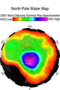 nts, conduct research on the surface of the planet. It will look for environments suitable for microbial life and, in that process, learn more about the history of water on Mars. Since Mars
 nts, conduct research on the surface of the planet. It will look for environments suitable for microbial life and, in that process, learn more about the history of water on Mars. Since Mars
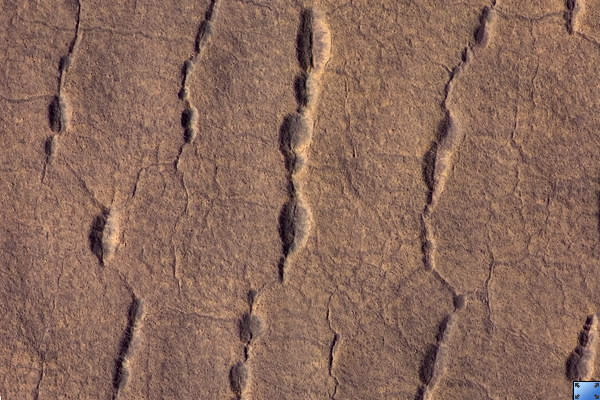
 has no liquid water, Phoenix is landing in the arctic region of Mars. In 2002, the Mars Odyssey Orbiter showed a high amount of subsurface water in the Arctic plains (image at left). The lander will, with its robotic arm dig through the protective top soil layer (image at right), reaching its way into the
water below. After digging,
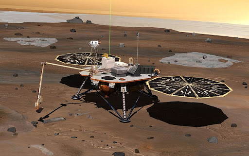
the lander will then bring in the soil and the water onboard on to the lander platform, where scientific instruments will analyze the samples.
The name Phoenix comes from the fact that the Phoenix program is very similar to the mythological namesake, which is a bird that is reborn from its ashes after it burns and dies. Many of the spacecraft's parts come from pervious projects. For example, the lander that the spacecraft is using has been modified from the Mars Surveyor 2001 lander.

The name Phoenix comes from the fact that the Phoenix program is very similar to the mythological namesake, which is a bird that is reborn from its ashes after it burns and dies. Many of the spacecraft's parts come from pervious projects. For example, the lander that the spacecraft is using has been modified from the Mars Surveyor 2001 lander.
Images from JPL, LPL, NASA.
May 19, 2008
Phoenix Is Go For Landing
 Phoenix is go for landing.
The Phoenix Spacecraft is currently being prepared for its landing on Mars, to take place on this Sunday, May 25, at about 7:30 P.M. NASA has put up many ways that you can stay informed and current with information about the landing. You can watch the broadcast of the event on TV on the NASA channel, if you get it. You can also read the Phoenix Landing Blog, with updated information as the landing date creeps closer. There is also a countdown on the Phoenix web page (if you have Mac OS 10.5, you can even create a widget of this countdown for Dashboard).
Also, as the moment of landing comes closer, I will try to post updated news about the spacecraft, the landing, and Mars.
Image from NASA.gov
April 1, 2008
Virgle

Virgle is an April Fool's Joke from Google, like previous ones that they have made, like Google Gulp and Google TiSP. It proposes a "Plan B," carried out over a hundred years, that will aim to colonize the red planet, Mars, by Virgin and Google teaming up. You can even fill out an application to become a "pioneer" in this endeavor, and watch video messages by Larry Page and Sergey Brin, cofounders of Google, and Richard Branson of Virgin. However, it is just an April Fool's joke. But Google points out in one of the pages on the Virgle website, "Virgle isn't real. Yet."
The information on Virgle's website are mostly all based on facts. In fact, if you read the FAQ on the website, you can learn a lot about Mars, terraformation, etc. As Google suggests on an obscure web page stating that Virgle is not real yet, all of this can become reality in the future. Terraforming, as Wikipedia explains, is the process that can make a planet or any other body in space have a similar environment to that of the Earth, to make it habitable for humans. This process is possible and may even take place in the near future. Also, Google suggested a self sustainable base on Mars. This too is also a viable possibility, that may take place as humans look to expand their horizons and settle out of Earth.
So, you can get a good laugh by going to Virgle, but keep in mind, all of this may be reality in the future.
Image from Google.com
The video messages of Larry Page, Sergey Brin, and Richard Branson are posted below:
March 10, 2008
Avalanche!

The High Resolution Imaging Experiment (HiRISE) on NASA's Mars Reconnaissance Orbiter has captured images of enormous clouds of dust and ice rolling down a steep slope (Click on the images at left for a larger view). The pictures were taken on February 19, and have just been recently released by NASA.
The images contain a steep slope more than 700m (2,300 ft.) tall. The location of these pictures had been repeatedly focused upon to check upon seasonal changes, specifically springtime changes in the carbon-dioxide frost covering on a dune. However, these set of images revealed these avalanches. "It really surprised me," said Ingrid Daubar Spitale of the University of Arizona at Tucson. "It's great to see something so dynamic on Mars. A lot of what we see there hasn't changed for millions of years." She was the first person to notice these avalanches on Mars.
NASA does not yet know what has caused these landslides on Mars. They say they will continue to monitor this region to see if these avalanches take place year round, or only in the springtime. A reddish layer rich in liquid water forms the majority of the slope. It is predicted that more ice fell than dust, leading to researchers studying the base of the slope to check its composition showing what part is ice. Researchers also predict that the blocks of ice falling in the avalanche probably turned from solid to gas, and will see if blocks of ice and other debris get smaller suggesting the theory. NASA hopes that the information gained from this will help us understand more about the Martian water cycle.
For more information, visit:
January 20, 2008
Clouds on Mars?!
 How can clouds exist on a planet that has a thin atmosphere and little moisture? Isn't Mars just a desert planet?
Most of the time, Mars is cloudless, but temperatures often plummet below the freezing point of carbon dioxide. Carbon dioxide, which is the most abundant gas in the Martian atmosphere, freezes into thick clouds due to the low temperature. The frozen carbon dioxide, called dry ice on Earth, can block the sun by 40 percent. The direct observations conducted by the European Space Agency's Mars Express have confirmed the clouds, whose existence has been previously suggested.
The clouds' density and makeup is very surprising. They are made up of CO2 particles larger than a micron(a micron is one thousandth of a millimeter) across.The particles normally would not be expected to form in the upper atmosphere, or stay in the air before returning to the surface. The clouds are also very high, reaching heights of more than 80 km (or about 50 miles) above the surface of Mars. The Martian clouds can also span hundreds of kilometers.
The French scientists who made the discovery know that the carbon dioxide clouds are most common near the equator of Mars, most probably because of the temperature variations there. Small amounts of warm gas rise above the planet, cooling off and condensing as they reach higher altitudes. When they release latent heat (the energy absorbed or released during a change of state), they rise even further. What these scientists haven't confirmed yet is what they condense around. Cloud droplets condense around sand or dust on our planet, but on Mars, there are many different possibilities. Martian dust kicked up by winds, or micrometeorites entering the atmosphere, or maybe even tiny crystals of water ice.
The importance of the discovery is that scientists can now learn more about the past climate of Mars. The planet is theorized to have been warmer billions of years ago, with CO2 clouds more covering up the atmosphere. The clouds could have played a big role in the global warming of Mars.
For more information, read the article on the ESA Mars Express website detailing the discovery. You can also read about Mars Express and the Climate of Mars on Wikipedia.
July 5, 2007
Mars Exploration Rover Mission in Possible Danger
A huge dust storm on Mars, covering the southern hemisphere of Mars almost completely, has put the future of the Mars Exploration Rovers Mission in danger. A smaller dust storm has also appeared elsewhere on Mars, adding further danger.
The largest dust storm has blocked the sun's light by almost 99 percent, threatening the solar powered Mars rovers. These rovers' power comes from their solar panels, which collect energy from the sun. If the sun is blocked off, the Martian rovers will not be able to get their energy, they will not be able to stay on and will be lost forever.
The dust storms on Mars are both immense, the larger one rising to cover from 230,000 square miles (600,000 square kilometers) to almost 7 million square miles (18 million square kilometers) in just two weeks. The smaller storm has risen, in just a few days, to cover 3 million square miles (7.7 million square kilometers). On Earth, their total combined area would be enough to darken the United States, Canada, and Greenland combined.
The large storms are actually numerous little storms combined. They kick up a lot of dust into the atmosphere, obscuring the surface of Mars. The atmosphere warms up, and continues a cycle of the whole process. However, this storm can be considered normal, because global dust storms on Mars take place about every three Martian years (or about six Earth years). The last one took place about two Martian years ago, so this one is happening almost on the right time.
Previous Martian dust devils have actually helped the Mars rovers, lifting off the dust settling on the rovers' solar panels and increasing the amount of energy they produced. As the current storms were developing they did the exact same thing to one of the rovers, Opportunity, as it was preparing to head down into Victoria Crater. But, the same storms are gaining power, and are blocking the sun lowering the Martian rover's energy to a dangerous level, just enough to power a 60-watt light bulb for five hours. A dead battery will not allow the robot explorer to keep its electronic components warm enough in the harsh cold on Mars.
The dust storms on Mars are growing very rapidly, and becoming a big threat to the continuation of the mission of the Mars Exploration Rovers. These storms may result in the loss of the very valuable rovers, which have given us an immense amount of knowledge about the red planet.
Below: A picture taken of Victoria Crater, taken by the Mars Reconnaissance Orbiter with the HiRISE (click here for more information about HiRISE) camera on board. Opportunity, and its tracks, can be seen on the edge of the crater at roughly the ten o'clock position. Click on the image to open a larger version. The rover will appear as a dot at the end of its tracks, which appear like fine lines. If you look closer, you can see the shadow of the mast of the rover.

For more information, visit:
The largest dust storm has blocked the sun's light by almost 99 percent, threatening the solar powered Mars rovers. These rovers' power comes from their solar panels, which collect energy from the sun. If the sun is blocked off, the Martian rovers will not be able to get their energy, they will not be able to stay on and will be lost forever.
The dust storms on Mars are both immense, the larger one rising to cover from 230,000 square miles (600,000 square kilometers) to almost 7 million square miles (18 million square kilometers) in just two weeks. The smaller storm has risen, in just a few days, to cover 3 million square miles (7.7 million square kilometers). On Earth, their total combined area would be enough to darken the United States, Canada, and Greenland combined.
The large storms are actually numerous little storms combined. They kick up a lot of dust into the atmosphere, obscuring the surface of Mars. The atmosphere warms up, and continues a cycle of the whole process. However, this storm can be considered normal, because global dust storms on Mars take place about every three Martian years (or about six Earth years). The last one took place about two Martian years ago, so this one is happening almost on the right time.
Previous Martian dust devils have actually helped the Mars rovers, lifting off the dust settling on the rovers' solar panels and increasing the amount of energy they produced. As the current storms were developing they did the exact same thing to one of the rovers, Opportunity, as it was preparing to head down into Victoria Crater. But, the same storms are gaining power, and are blocking the sun lowering the Martian rover's energy to a dangerous level, just enough to power a 60-watt light bulb for five hours. A dead battery will not allow the robot explorer to keep its electronic components warm enough in the harsh cold on Mars.
The dust storms on Mars are growing very rapidly, and becoming a big threat to the continuation of the mission of the Mars Exploration Rovers. These storms may result in the loss of the very valuable rovers, which have given us an immense amount of knowledge about the red planet.
Below: A picture taken of Victoria Crater, taken by the Mars Reconnaissance Orbiter with the HiRISE (click here for more information about HiRISE) camera on board. Opportunity, and its tracks, can be seen on the edge of the crater at roughly the ten o'clock position. Click on the image to open a larger version. The rover will appear as a dot at the end of its tracks, which appear like fine lines. If you look closer, you can see the shadow of the mast of the rover.

For more information, visit:
- Space.com
- Wikipedia(Mars Exploration Rover and Victoria Crater)
June 6, 2007
View High Resolution Images of Mars
High resolution images of features of Mars are available to the world now, through a new website released by the University of Arizona. Their project, entitled HiRISE (High Resolution Imaging Science Experiment), is introducing to the public more than 1.7 terabytes of data from the HiRISE camera put on the Mars Reconnaissance Orbiter, the most powerful camera to leave the Earth's orbit.
For more information, visit:
April 16, 2007
NASA's Mars Global Surveyor Has Been Lost

The Mars Global Surveyor was launched in 1996, and had operated four times as long as it had been intended. After a series of events including on board computer memory and ground commands, the spacecraft was unable to orient itself due to battery failure. Last communicating on November 2, 2006, it succumbed to this fate 11 hours after this. This article on NASA's website reports what had happened:
On Nov. 2, after the spacecraft was ordered to perform a routine adjustment of its solar panels, the spacecraft reported a series of alarms, but indicated that it had stabilized. That was its final transmission. Subsequently, the spacecraft reoriented to an angle that exposed one of two batteries carried on the spacecraft to direct sunlight. This caused the battery to overheat and ultimately led to the depletion of both batteries. Incorrect antenna pointing prevented the orbiter from telling controllers its status, and its programmed safety response did not include making sure the spacecraft orientation was thermally safe.The Mars Global Surveyor has given us a wealth of information about the red planet, including evidence of water on Mars.
To learn more about this, visit:
Subscribe to:
Posts (Atom)